
Thank you for supporting this site ❤️
Make a donation
Make a donation
Parbati Kunda topographic map
Click on the map to display elevation.
Thank you for supporting this site ❤️
Make a donation
Make a donation
About this map
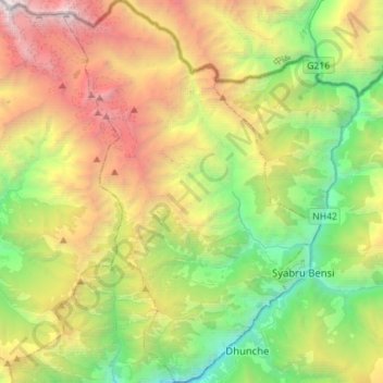
Name: Parbati Kunda topographic map, elevation, terrain.
Location: Parbati Kunda, Rasuwa, Bagmati Province, Nepal (28.09203 85.15961 28.34031 85.35042)
Average elevation: 3,310 m
Minimum elevation: 1,107 m
Maximum elevation: 6,990 m
Thank you for supporting this site ❤️
Make a donation
Make a donation
Other topographic maps
Click on a map to view its topography, its elevation and its terrain.