
Thank you for supporting this site ❤️
Make a donation
Make a donation
Rajpur topographic map
Click on the map to display elevation.
Thank you for supporting this site ❤️
Make a donation
Make a donation
About this map
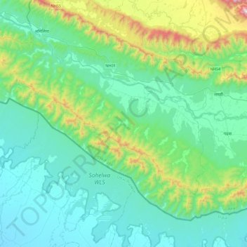
Name: Rajpur topographic map, elevation, terrain.
Location: Rajpur, Dang, 21900, Nepal (27.67739 82.06387 27.97616 82.49850)
Average elevation: 350 m
Minimum elevation: 118 m
Maximum elevation: 1,349 m
Thank you for supporting this site ❤️
Make a donation
Make a donation
Other topographic maps
Click on a map to view its topography, its elevation and its terrain.