
Thank you for supporting this site ❤️
Make a donation
Make a donation
Dolpa topographic map
Click on the map to display elevation.
Thank you for supporting this site ❤️
Make a donation
Make a donation
Dolpa
Dolpa is the largest district of Nepal covering 5.36% of the total landmass of the country. It is located at 28°43’N to 29°43’N latitude and 82°23’E to 83°41’E longitude. Elevation ranges from 1,525 to 7,625 m (5,003 to 25,016 ft). The district borders Tibet on the north and northeast, Jumla and Mugu districts on the west, Myagdi, Jajarkot, Western and Eastern Rukum on the south, and Mustang on the east.
Thank you for supporting this site ❤️
Make a donation
Make a donation
About this map
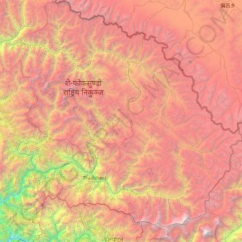
Name: Dolpa topographic map, elevation, terrain.
Location: Dolpa, Karnali Province, Nepal (28.72190 82.39256 29.70741 83.67995)
Average elevation: 4,555 m
Minimum elevation: 972 m
Maximum elevation: 8,065 m
Thank you for supporting this site ❤️
Make a donation
Make a donation
Other topographic maps
Click on a map to view its topography, its elevation and its terrain.