
Thank you for supporting this site ❤️
Make a donation
Make a donation
Shantinagar topographic map
Click on the map to display elevation.
Thank you for supporting this site ❤️
Make a donation
Make a donation
About this map
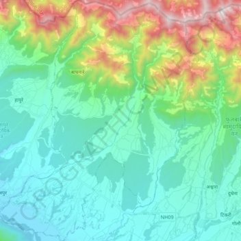
Name: Shantinagar topographic map, elevation, terrain.
Location: Shantinagar, Dang, Lumbini Province, Nepal (28.10414 82.11458 28.25134 82.25371)
Average elevation: 884 m
Minimum elevation: 529 m
Maximum elevation: 2,047 m
Thank you for supporting this site ❤️
Make a donation
Make a donation
Other topographic maps
Click on a map to view its topography, its elevation and its terrain.