
Thank you for supporting this site ❤️
Make a donation
Make a donation
Dharan topographic map
Click on the map to display elevation.
Thank you for supporting this site ❤️
Make a donation
Make a donation
About this map
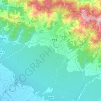
Name: Dharan topographic map, elevation, terrain.
Location: Dharan, Sunsari, Koshi Province, Nepal (26.71205 87.19811 26.87889 87.35381)
Average elevation: 478 m
Minimum elevation: 102 m
Maximum elevation: 1,876 m
Thank you for supporting this site ❤️
Make a donation
Make a donation