
Make a donation
Dhankuta topographic map
Click on the map to display elevation.
Make a donation
Dhankuta
Dhankuta is a mid-hill district of eastern hill region of Nepal. It is situated between 26°53' to 27°19' north latitude and 87°8' to 88°33' east longitude. Total area of the district is 888.7 square kilometres (343.1 sq mi) and it is located at 243 metres (9,600 in) to 629 metres (24,800 in) of elevation above sea level.
Make a donation
About this map
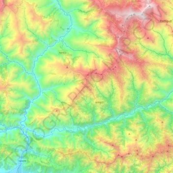
Name: Dhankuta topographic map, elevation, terrain.
Location: Dhankuta, Koshi Province, Nepal (26.84575 87.14832 27.19038 87.57997)
Average elevation: 1,098 m
Minimum elevation: 105 m
Maximum elevation: 2,982 m
Make a donation
Other topographic maps
Click on a map to view its topography, its elevation and its terrain.
Lhotse
Nepal > Koshi Province > Solukhumbu
Lhotse (Nepali: ल्होत्से, romanized: L'hōtsē [lotse]; Standard Tibetan: ལྷོ་རྩེ, romanized: lho tse, lit. 'South Peak' [l̥otse]; Chinese: 洛子峰) is the fourth-highest mountain on Earth, after Mount Everest, K2, and Kangchenjunga. At an elevation of 8,516 metres (27,940…
Average elevation: 7,391 m
Phaplu
Nepal > Koshi Province > Solukhumbu
Phaphlu is a mountainous town in north-east Nepal, approximately 270 kilometres east of the Nepalese capital, Kathmandu. The altitude of the village is 2,413 m.
Average elevation: 2,518 m
Make a donation
Ilam
Nepal > Koshi Province > Ilam
The word ‘Ilam’ comprises two words-‘I’ and ‘Lam’. In Limbu language, the word ‘I’ means ‘winding’ and ‘lam’ denotes the way. The topography of this Ilam aptly depicts several winding paths crisscrossing.
Average elevation: 919 m
Make a donation
Gokyo
Nepal > Koshi Province > Solukhumbu
The village is located at an elevation of 4,750 m (15,584 ft), making it one of the highest settlements in Nepal and in the world. Almost all the buildings are guest houses for trekkers. The people who live in the village leave during the winter and move to other (lower) villages such as Namche Bazaar.
Average elevation: 4,919 m
Make a donation