
Thank you for supporting this site ❤️
Make a donation
Make a donation
Dungeshwor topographic map
Click on the map to display elevation.
Thank you for supporting this site ❤️
Make a donation
Make a donation
About this map
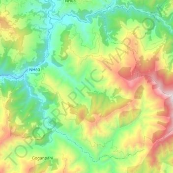
Name: Dungeshwor topographic map, elevation, terrain.
Location: Dungeshwor, Dailekh, Karnali Pradesh, Nepal (28.69809 81.64718 28.80991 81.79359)
Average elevation: 1,313 m
Minimum elevation: 653 m
Maximum elevation: 2,544 m
Thank you for supporting this site ❤️
Make a donation
Make a donation
Other topographic maps
Click on a map to view its topography, its elevation and its terrain.