
Vetle Skagastølstind topographic map
Interactive map
Click on the map to display elevation.
About this map
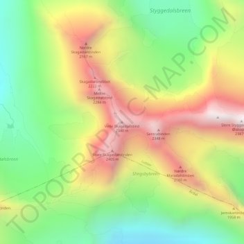
Name: Vetle Skagastølstind topographic map, elevation, terrain.
Location: Vetle Skagastølstind, Luster, Sogn og Fjordane, Norway (61.46442 7.87417 61.46452 7.87427)
Average elevation: 1,783 m
Minimum elevation: 1,317 m
Maximum elevation: 2,358 m
Other topographic maps
Click on a map to view its topography, its elevation and its terrain.
Sande
Sande, Holmestrand, Vestfold og Telemark, 3070, Norway
Average elevation: 37 m
Porsgrunn
Porsgrunn, Vestfold og Telemark, Norway
Average elevation: 87 m
Olonkin City
Norway > Jan Mayen > Olonkin City
Olonkin City, Jan Mayen, Norway
Average elevation: 153 m