Geolocate

Alver topographic map

Interactive map

Click on the map to display elevation.

About this map

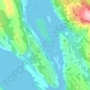
Name: Alver topographic map, elevation, terrain.

Location: Alver, Vestland, Norway (60.57918 5.21905 60.58022 5.22042)

Average elevation: 45 m

Minimum elevation: -1 m

Maximum elevation: 220 m

Other topographic maps

Click on a map to view its topography, its elevation and its terrain.

Nordfjordeid

Norway > Vestland

Average elevation: 322 m

Olden

Norway > Vestland

Average elevation: 398 m

Bergen

Norway > Vestland

Average elevation: 111 m

Ullensvang

Norway > Vestland

Average elevation: 1,049 m

Haukland

Norway > Vestland

Average elevation: 47 m

Manger

Norway > Vestland

Average elevation: 23 m

Masfjorden

Norway > Vestland

Average elevation: 305 m

Vik

Norway > Vestland

Average elevation: 739 m

Bergen

Norway > Vestland

Average elevation: 125 m