
Thank you for supporting this site ❤️
Make a donation
Make a donation
Hamar topographic map
Click on the map to display elevation.
Thank you for supporting this site ❤️
Make a donation
Make a donation
About this map
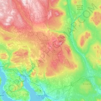
Name: Hamar topographic map, elevation, terrain.
Location: Hamar, Innlandet, Norway (60.76898 10.98098 61.23604 11.27969)
Average elevation: 445 m
Minimum elevation: 120 m
Maximum elevation: 1,024 m
Thank you for supporting this site ❤️
Make a donation
Make a donation
Other topographic maps
Click on a map to view its topography, its elevation and its terrain.
Snøhetta
Snøhetta is the highest mountain in the Dovrefjell mountain range in Norway. At 2,286 metres (7,500 ft), it is the highest mountain in Norway outside the Jotunheimen range, making it the 24th highest peak in Norway, based on a 30-metre (98 ft) topographic prominence cutoff. At 1,675 metres (5,495 ft), its…
Average elevation: 1,913 m
Thank you for supporting this site ❤️
Make a donation
Make a donation