
Akershus topographic map
Interactive map
Click on the map to display elevation.
About this map
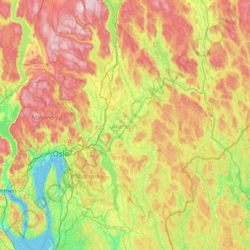
Name: Akershus topographic map, elevation, terrain.
Location: Akershus, Norway (59.47188 10.32847 60.60515 11.92698)
Average elevation: 252 m
Minimum elevation: -3 m
Maximum elevation: 824 m
Other topographic maps
Click on a map to view its topography, its elevation and its terrain.
Snøhetta
Snøhetta is the highest mountain in the Dovrefjell mountain range in Norway. At 2,286 metres (7,500 ft), it is the highest mountain in Norway outside the Jotunheimen range, making it the 24th highest peak in Norway, based on a 30-metre (98 ft) topographic prominence cutoff. At 1,675 metres (5,495 ft), its…
Average elevation: 1,913 m
Trondheim
Trondheim is situated where the River Nidelva meets Trondheim Fjord with an excellent harbour and sheltered condition. The river used to be deep enough for most boats in the Middle Ages. An avalanche of mud and stones made it less navigable and partly ruined the harbour in the mid-17th century. The…
Average elevation: 118 m