
奥穂高岳 topographic map
Interactive map
Click on the map to display elevation.
About this map
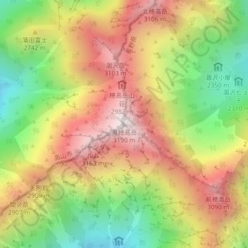
Name: 奥穂高岳 topographic map, elevation, terrain.
Location: 奥穂高岳, 松本市, 長野県, 日本 (36.28925 137.64786 36.28935 137.64796)
Average elevation: 2,673 m
Minimum elevation: 2,146 m
Maximum elevation: 3,185 m
穂高岳(ほたかだけ)は、中部山岳国立公園の飛驒山脈にある標高3,190mの山(奥穂高岳)を主峰とする山々の総称。日本第3位の高峰。日本百名山、新日本百名山及び花の百名山に選定されている。これらの山々は穂高連峰とも称され、槍ヶ岳とともに槍・穂高連峰とも称される。
Other topographic maps
Click on a map to view its topography, its elevation and its terrain.