
赤沢山 topographic map
Interactive map
Click on the map to display elevation.
About this map
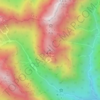
Name: 赤沢山 topographic map, elevation, terrain.
Location: 赤沢山, 松本市, 長野県, 日本 (36.32916 137.67969 36.32926 137.67979)
Average elevation: 2,242 m
Minimum elevation: 1,715 m
Maximum elevation: 2,748 m
Other topographic maps
Click on a map to view its topography, its elevation and its terrain.