
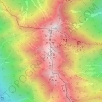
大喰岳 topographic map
Interactive map
Click on the map to display elevation.
About this map
Name: 大喰岳 topographic map, elevation, terrain.
Location: 大喰岳, 松本市, 長野県, 日本 (36.33576 137.64601 36.33586 137.64611)
Average elevation: 2,634 m
Minimum elevation: 1,985 m
Maximum elevation: 3,129 m
大喰岳(おおばみだけ)は、長野県松本市と岐阜県高山市にまたがる飛騨山脈南部に位置し、槍ヶ岳の南側に対峙する標高3,101 mの山。
Other topographic maps
Click on a map to view its topography, its elevation and its terrain.