
County Kerry topographic map
Interactive map
Click on the map to display elevation.
About this map
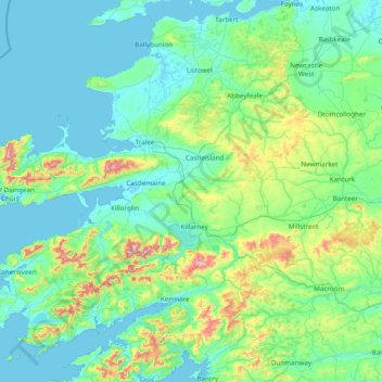
Name: County Kerry topographic map, elevation, terrain.
Location: County Kerry, Munster, Irland (51.68820 -10.66262 52.60245 -9.11875)
Average elevation: 123 m
Minimum elevation: -2 m
Maximum elevation: 971 m
Die Corcu Duibne hatten auch beeindruckende architektonische Fähigkeiten. Sie bauten die spektakulären Promontory Forts Caherconree und Dunbeg Fort. Die Milesier waren die dritte Gruppe, die sich in der Region ansiedelte. Nach der Legende sollen sie Irland etwa 100 v. Chr. erobert haben. Die letzte geschichtlich belegte Zuwanderung erfolgte indes 2500 v. Chr. durch die Menschen der Glockenbecherkultur. Nach ihrer Landung bei Waterville fochten die Milesier mehrere Schlachten gegen die mythischen Túatha Dé Danann, die ihren Höhepunkt in der Schlacht am Sliabh Mis fanden, die die Milesier gewannen. Ihre Königin Scota wurde getötet und in einem Tal oberhalb von Tralee bestattet. Das Gebiet ist heute als Glen Scota bekannt, und das Grab der Königin soll unter alten Steinen liegen.
Other topographic maps
Click on a map to view its topography, its elevation and its terrain.
Carrickmacross-Castleblaney Municipal District
Carrickmacross-Castleblaney Municipal District, County Monaghan, Ulster, Irland
Average elevation: 114 m
Killaloe Municipal District
Killaloe Municipal District, County Clare, Munster, Irland
Average elevation: 85 m
Lear
Lear, Canningstown ED, Bailieborough-Cootehill Municipal District, County Cavan, Ulster, Irland
Average elevation: 189 m
Dunmore East
Dunmore East, County Waterford, Munster, X91 C677, Irland
Average elevation: 36 m
Knockanteedan
Knockanteedan, Glassamucky, Bohernabreena DED 1986, South Dublin, County Dublin, Leinster, D24 T651, Irland
Average elevation: 243 m
Cloncarney
Irland > County Donegal > Letterkenny Municipal District
Cloncarney, Templedouglas ED, Letterkenny Municipal District, County Donegal, Irland
Average elevation: 123 m
Little Sugar Loaf
Little Sugar Loaf, The Municipal District of Bray, County Wicklow, Leinster, A63 FX34, Irland
Average elevation: 131 m
Ballymahon
Ballymahon, Castlerickard ED, The Municipal District of Trim, County Meath, Leinster, Irland
Average elevation: 66 m
Ballykeeran
Ballykeeran, The Municipal District of Athlone — Moate, County Westmeath, Leinster, N37 VK74, Irland
Average elevation: 47 m
Glencolumbkille
Glencolumbkille, County Donegal, Ulster, Irland
Average elevation: 95 m
Glenties Municipal District
Glenties Municipal District, County Donegal, Ulster, Irland
Average elevation: 90 m
Ennis Municipal District
Ennis Municipal District, County Clare, Munster, Irland
Average elevation: 39 m
Swanlinbar
Swanlinbar, Cavan-Belturbet Municipal District, County Cavan, Irland
Average elevation: 97 m
Gubnafarna
Gubnafarna, Kinawley ED, Cavan-Belturbet Municipal District, County Cavan, Irland
Average elevation: 178 m
The Municipal District of Muinebeag
The Municipal District of Muinebeag, County Carlow, Leinster, Irland
Average elevation: 129 m
Naas
Naas, The Municipal District of Naas, County Kildare, Leinster, Irland
Average elevation: 99 m
Goatstown
Goatstown, Dún Laoghaire-Rathdown, County Dublin, Leinster, D14 WR83, Irland
Average elevation: 57 m
Derrycastle
Derrycastle, The Municipal District of Nenagh, County Tipperary, Munster, Irland
Average elevation: 152 m
The Municipal District of Nenagh
The Municipal District of Nenagh, County Tipperary, Munster, Irland
Average elevation: 116 m
Ballybay-Clones Municipal District
Ballybay-Clones Municipal District, County Monaghan, Ulster, Irland
Average elevation: 114 m
The Municipal District of Gorey — Kilmuckridge
The Municipal District of Gorey — Kilmuckridge, County Wexford, Leinster, Irland
Average elevation: 58 m
Curraheen
Curraheen, Glanbehy ED, Kenmare Municipal District, County Kerry, Munster, Irland
Average elevation: 124 m
Balliny South
Balliny South, Derreen ED, West Clare Municipal District, County Clare, Munster, Irland
Average elevation: 253 m
Kenmare Municipal District
Kenmare Municipal District, County Kerry, Munster, Irland
Average elevation: 98 m
Glenmore
Glenmore, Rathcor ED, The Municipal District of Dundalk, County Louth, Leinster, Irland
Average elevation: 241 m
The Municipal District of Baltinglass
The Municipal District of Baltinglass, County Wicklow, Leinster, Irland
Average elevation: 182 m
Ballynabarney
Ballynabarney, Wingfield ED, The Municipal District of Gorey — Kilmuckridge, County Wexford, Leinster, Irland
Average elevation: 241 m
An Coimín Theas
An Coimín Theas, Toghroinn ceantair Dún Chaoin, Kenmare Municipal District, County Kerry, Munster, Irland
Average elevation: 248 m
Abbeyfeale
Irland > County Limerick > The Municipal District of Newcastle West
Abbeyfeale, The Municipal District of Newcastle West, County Limerick, Munster, Irland
Average elevation: 150 m
The Municipal District of Kanturk – Mallow
The Municipal District of Kanturk – Mallow, County Cork, Munster, Irland
Average elevation: 182 m
Bridgetown
Bridgetown, Clonea, The Municipal District of Comeragh, County Waterford, Munster, Irland
Average elevation: 89 m
Slieve League
Slieve League, Donegal Municipal District, County Donegal, Irland
Average elevation: 233 m
Tuam Municipal District
Tuam Municipal District, County Galway, Connacht, Irland
Average elevation: 54 m
Arless ED
Arless ED, The Municipal District of Graiguecullen — Portarlington, County Laois, Leinster, Irland
Average elevation: 97 m
Tullagreen
Irland > County Cork > Municipal District of Cobh
Tullagreen, Carrigtohill ED, Municipal District of Cobh, County Cork, Munster, Irland
Average elevation: 12 m
Loughrea Municipal District
Loughrea Municipal District, County Galway, Connacht, Irland
Average elevation: 69 m
Brandon Hill
Brandon Hill, The Municipal District of Callan — Thomastown, County Kilkenny, Leinster, R95 EKN5, Irland
Average elevation: 294 m
The Municipal District of Navan
The Municipal District of Navan, County Meath, Leinster, Irland
Average elevation: 62 m
Garvagh/Arigna ED
Garvagh/Arigna ED, Manorhamilton Municipal District, County Leitrim, Connacht, Irland
Average elevation: 201 m
Westport-Belmullet Municipal District
Westport-Belmullet Municipal District, County Mayo, Connacht, Irland
Average elevation: 62 m
Scarriff
Irland > County Clare > Scarriff
Scarriff, Killaloe Municipal District, County Clare, Munster, Irland
Average elevation: 52 m
Ennistymon
Ennistymon, West Clare Municipal District, County Clare, Munster, Irland
Average elevation: 61 m
Mountshannon
Irland > County Clare > Mountshannon
Mountshannon, Killaloe Municipal District, County Clare, Munster, Irland
Average elevation: 52 m
Borrisoleigh
Irland > County Tipperary > Borrisoleigh
Borrisoleigh, The Municipal District of Thurles, County Tipperary, Munster, Irland
Average elevation: 128 m