
Glenties Municipal District topographic map
Interactive map
Click on the map to display elevation.
About this map
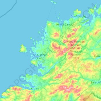
Name: Glenties Municipal District topographic map, elevation, terrain.
Location: Glenties Municipal District, County Donegal, Ulster, Irland (54.68883 -8.62103 55.27605 -7.83491)
Average elevation: 90 m
Minimum elevation: -2 m
Maximum elevation: 724 m
Other topographic maps
Click on a map to view its topography, its elevation and its terrain.
Cloncarney
Irland > County Donegal > Letterkenny Municipal District
Cloncarney, Templedouglas ED, Letterkenny Municipal District, County Donegal, Irland
Average elevation: 123 m
Glencolumbkille
Glencolumbkille, County Donegal, Ulster, Irland
Average elevation: 95 m
Slieve League
Slieve League, Donegal Municipal District, County Donegal, Irland
Average elevation: 233 m