
Loughrea Municipal District topographic map
Interactive map
Click on the map to display elevation.
About this map
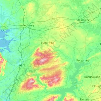
Name: Loughrea Municipal District topographic map, elevation, terrain.
Location: Loughrea Municipal District, County Galway, Connacht, Irland (52.96818 -9.05179 53.33349 -8.06208)
Average elevation: 69 m
Minimum elevation: -1 m
Maximum elevation: 392 m
Other topographic maps
Click on a map to view its topography, its elevation and its terrain.
Tuam Municipal District
Tuam Municipal District, County Galway, Connacht, Irland
Average elevation: 54 m
Galway Bay - Cuan na Gaillimhe
Galway Bay - Cuan na Gaillimhe, County Galway, Connacht, Irland
Average elevation: 35 m
Knocknagoneen
Irland > County Galway > Cathair na Gaillimhe > Galway Municipal District
Knocknagoneen, Knocknacarragh, Galway Municipal District, Cathair na Gaillimhe, County Galway, Connacht, H91 R6PW, Irland
Average elevation: 5 m