
Balliny South topographic map
Interactive map
Click on the map to display elevation.
About this map
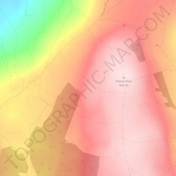
Name: Balliny South topographic map, elevation, terrain.
Average elevation: 253 m
Minimum elevation: 40 m
Maximum elevation: 341 m
Other topographic maps
Click on a map to view its topography, its elevation and its terrain.
Killaloe Municipal District
Killaloe Municipal District, County Clare, Munster, Irland
Average elevation: 85 m
Ennis Municipal District
Ennis Municipal District, County Clare, Munster, Irland
Average elevation: 39 m
Scarriff
Irland > County Clare > Scarriff
Scarriff, Killaloe Municipal District, County Clare, Munster, Irland
Average elevation: 52 m
Mountshannon
Irland > County Clare > Mountshannon
Mountshannon, Killaloe Municipal District, County Clare, Munster, Irland
Average elevation: 52 m
Shannon
Irland > County Clare > Shannon
Shannon, Shannon Municipal District, County Clare, Munster, V14 AK19, Irland
Average elevation: 10 m
Liscannor
Irland > County Clare > Liscannor
Liscannor, Liscannor ED, West Clare Municipal District, County Clare, Munster, Irland
Average elevation: 12 m
Loop Head
Loop Head, Kilbaha South, Kilballyowen ED, West Clare Municipal District, County Clare, Munster, Irland
Average elevation: 5 m
Doolin
Irland > County Clare > Doolin
Doolin, Killilagh ED, West Clare Municipal District, County Clare, Munster, V95-V9P1, Irland
Average elevation: 38 m
West Clare Municipal District
West Clare Municipal District, County Clare, Munster, Irland
Average elevation: 37 m