
Little Sugar Loaf topographic map
Interactive map
Click on the map to display elevation.
About this map
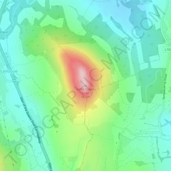
Name: Little Sugar Loaf topographic map, elevation, terrain.
Average elevation: 131 m
Minimum elevation: 53 m
Maximum elevation: 331 m
Other topographic maps
Click on a map to view its topography, its elevation and its terrain.
The Municipal District of Baltinglass
The Municipal District of Baltinglass, County Wicklow, Leinster, Irland
Average elevation: 182 m
Wicklow Mountains National Park
Wicklow Mountains National Park, County Wicklow, Leinster, Irland
Average elevation: 322 m