
Glencolumbkille topographic map
Interactive map
Click on the map to display elevation.
About this map
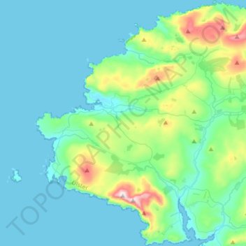
Name: Glencolumbkille topographic map, elevation, terrain.
Location: Glencolumbkille, County Donegal, Ulster, Irland (54.61844 -8.83471 54.77971 -8.59534)
Average elevation: 95 m
Minimum elevation: -1 m
Maximum elevation: 593 m
Es ist eine etwa zwei Meter tiefe Röhre, die aber aufgrund fehlender Tritt- und Haltemöglichkeiten nicht benutzt werden kann. Von der früheren Erforschung ist bekannt, dass die Röhre neben einem rechteckigen, über sechs Meter langen, etwa 2,5 Meter breiten und 1,6 m hohen Raum endet, in den man durch einen Schlupf (1,0 × 0,5 m) gelangt. Im Osten liegt hinter einem niedrigen Schlupf ein über sechs Meter langer, etwa 1,0 m breiter und etwa 1,0 m hoher Gang. In der Mitte der Westwand ist ein Schlupf in 0,4 m Höhe über dem Grund. Er führt in einen weiteren, über neun Meter langen, zumeist schmalen und niedrigen Gang. Ein zweites Souterrain liegt (zerstört) bei der Polizeistation.
Other topographic maps
Click on a map to view its topography, its elevation and its terrain.
Cloncarney
Irland > County Donegal > Letterkenny Municipal District
Cloncarney, Templedouglas ED, Letterkenny Municipal District, County Donegal, Irland
Average elevation: 123 m
Glenties Municipal District
Glenties Municipal District, County Donegal, Ulster, Irland
Average elevation: 90 m
Slieve League
Slieve League, Donegal Municipal District, County Donegal, Irland
Average elevation: 233 m