
Kenmare Municipal District topographic map
Interactive map
Click on the map to display elevation.
About this map
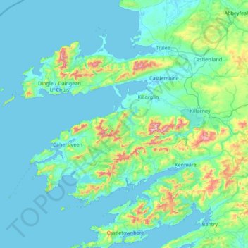
Name: Kenmare Municipal District topographic map, elevation, terrain.
Location: Kenmare Municipal District, County Kerry, Munster, Irland (51.68820 -10.61844 52.33778 -9.27401)
Average elevation: 98 m
Minimum elevation: -3 m
Maximum elevation: 1,001 m
Other topographic maps
Click on a map to view its topography, its elevation and its terrain.
Curraheen
Curraheen, Glanbehy ED, Kenmare Municipal District, County Kerry, Munster, Irland
Average elevation: 124 m
An Coimín Theas
An Coimín Theas, Toghroinn ceantair Dún Chaoin, Kenmare Municipal District, County Kerry, Munster, Irland
Average elevation: 248 m
Valentia
Valentia, Kenmare Municipal District, County Kerry, Munster, Irland
Average elevation: 39 m
Ross Behy
Ross Behy, Glanbehy ED, Kenmare Municipal District, County Kerry, Munster, V93 H5W9, Irland
Average elevation: 57 m