
Laksevåg topographic map
Interactive map
Click on the map to display elevation.
About this map
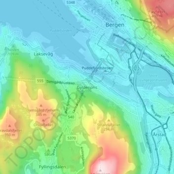
Name: Laksevåg topographic map, elevation, terrain.
Location: Laksevåg, Gyldenpris, Bergen, Hordaland, 5056, Norway (60.35987 5.29293 60.39987 5.33293)
Average elevation: 110 m
Minimum elevation: -5 m
Maximum elevation: 471 m
Other topographic maps
Click on a map to view its topography, its elevation and its terrain.
Jesus Lever-steinen
Jesus Lever-steinen, Løvstien, Solheims Boretslag, Solheim, Årstad, Gyldenpris, Bergen, Hordaland, 5057, Norway
Average elevation: 100 m