
町田市 topographic map
Interactive map
Click on the map to display elevation.
About this map
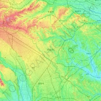
Name: 町田市 topographic map, elevation, terrain.
Location: 町田市, 東京都, 日本 (35.50122 139.26880 35.62350 139.50742)
Average elevation: 81 m
Minimum elevation: 7 m
Maximum elevation: 217 m
市域の大部分が多摩丘陵に属し、地形的には同丘陵の北部、相模原台地の北東の縁であり、ほとんどが丘陵地帯である。最高地点は西端にある草戸山(標高364m)。平地は町田駅付近や西および南を流れる境川・ほぼ中央を流れる鶴見川とその支流恩田川近辺など少ない。ほぼ町田街道を分水嶺に、北側が多摩川水系および鶴見川水系、南側が境川水系である。
Other topographic maps
Click on a map to view its topography, its elevation and its terrain.