
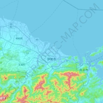
伊勢市 topographic map
Interactive map
Click on the map to display elevation.
About this map
Name: 伊勢市 topographic map, elevation, terrain.
Location: 伊勢市, 三重県, 516-0037, 日本 (34.38472 136.63261 34.65348 136.82099)
Average elevation: 52 m
Minimum elevation: -5 m
Maximum elevation: 589 m
志摩半島の北東部に位置する。市の北部は平地(伊勢平野の南端)であり、伊勢湾に面している。南部は標高100m - 500mの丘陵・山地が広がる。
Other topographic maps
Click on a map to view its topography, its elevation and its terrain.