
石巻市 topographic map
Interactive map
Click on the map to display elevation.
About this map
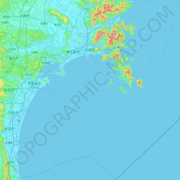
Name: 石巻市 topographic map, elevation, terrain.
Location: 石巻市, 宮城県, 日本 (37.88678 141.16115 38.64087 141.97443)
Average elevation: 18 m
Minimum elevation: -3 m
Maximum elevation: 498 m
旧北上川右岸から西側の河南地区、桃生地区は仙台平野の東端部に位置し、石巻平野と北上川がもたらした肥沃な土壌から稲作を中心とした農業が盛んである。一方の旧北上川左岸から東の地域は北上山地とリアス式海岸によって複雑な地形をしており、平地が少ないため農業は西部と比べて割合は低い。東部では漁業や石巻湾内での養殖業などが盛んである。市の中央部の上品山には牧場があり、周辺では畜産業も行われている。
Other topographic maps
Click on a map to view its topography, its elevation and its terrain.