
Make a donation
Italy topographic map
Click on the map to display elevation.
Make a donation
Italy
Italy's topography is characterized by its striking contrast of mountainous regions and coastal plains, offering some of the most varied landscapes in Europe. The northern boundary is dominated by the Alps, which rise dramatically with peaks exceeding 13,000 feet (3,962 meters), creating a rugged frontier with France, Switzerland, Austria, and Slovenia. These mountains give way to the expansive Po Valley, the country's largest plain, which is framed by hills and provides fertile agricultural land. Extending down the spine of the Italian peninsula is the Apennine mountain range, which runs southward and gradually narrows as it approaches the Mediterranean, contributing to a varied climate and rich biodiversity. Southern Italy is marked by volcanic activity, most notably Mount Vesuvius and the Aeolian Islands, while the coastal areas are bordered by several seas, including the Adriatic to the east and the Tyrrhenian to the west. This diverse topography not only shapes the natural beauty of Italy but also influences its culture and history, with many regions developing independently due to the geographical barriers.
Make a donation
About this map
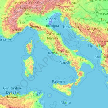
Name: Italy topographic map, elevation, terrain.
Location: Italy (35.28896 6.62727 47.09215 18.78447)
Average elevation: 293 m
Minimum elevation: -6 m
Maximum elevation: 4,188 m
Make a donation
Other topographic maps
Click on a map to view its topography, its elevation and its terrain.
Mumbai
Mumbai lies at the mouth of the Ulhas River on the western coast of India, in the coastal region known as the Konkan. It sits on Salsette Island (Sashti Island), which it partially shares with the Thane district. Mumbai is bounded by the Arabian Sea to the west. Many parts of the city lie just above sea level,…
Average elevation: 13 m
Make a donation
Maharashtra
Maharashtra is the third largest state by area in India. The Western Ghats better known as Sahyadri, are a hilly range running parallel to the coast, at an average elevation of 1,200 metres (4,000 ft). Kalsubai, a peak in the Sahyadris, near Nashik city is the highest elevated point in Maharashtra. To the west…
Average elevation: 478 m
Thiruvananthapuram
India > Kerala > Thiruvananthapuram
Thiruvananthapuram is built on seven hills by the seashore and is at 8°30′N 76°54′E / 8.5°N 76.9°E / 8.5; 76.9 on the west coast, near the southern tip of mainland India. The city is on the west coast of India and is bounded by the Laccadive Sea to its west and the Western Ghats to its east.…
Average elevation: 33 m
Make a donation
Rishikesh
India > Uttarakhand > Rishikesh
Rishikesh is at 30°06′12″N 78°17′41″E / 30.103368°N 78.294754°E / 30.103368; 78.294754. It has an average elevation of 372 metres (1,220 ft). The town is located in the Tehri Garhwal region of the northern Indian state of Uttarakhand.
Average elevation: 497 m
Guwahati
Professor Abani Kumar Bhagawati of Gauhati University stated that since before there were sufficient wetlands to absorb rainwater and channels to carry excess water to the Brahmaputra, the city did not experience floods. However, human interference has disrupted the natural topography, leading to the current…
Average elevation: 113 m
Dehradun
India > Uttarakhand > Dehradun
The city of Dehradun mainly lies in Doon Valley and is at a varying height from 410 m (1,350 ft) in Clement Town to above 700 m (2,300 ft) at Malsi which is 15 km (9.3 mi) from the city. However, the average elevation is 450 m (1,480 ft) above sea level. Malsi is the starting point of Lesser Himalayan Range…
Average elevation: 904 m
Vadodara
India > Gujarat > Vadodara Rural Taluka
Vadodara is located at 22°18′N 73°11′E / 22.30°N 73.19°E / 22.30; 73.19 in western India at an elevation of 39 metres (128 ft). It is the tenth-largest city in India with an area of 400 square kilometres (150 sq mi) and a population of 3.5 million, according to the 2010–11 census. The city…
Average elevation: 36 m
Make a donation
Navi Mumbai
India > Maharashtra > Thane > Navi Mumbai
Navi Mumbai (Marathi pronunciation: , also known by its former name New Bombay), is a planned city off the west coast of the Indian state of Maharashtra in Konkan division. The city is divided into two parts, North Navi Mumbai and South Navi Mumbai, for the individual development of Panvel Mega City, which…
Average elevation: 30 m
Make a donation
Make a donation
Alibag
India > Maharashtra > Alibag Taluka
Alibag is located about 120 km south of Mumbai, at 18°38′29″N 72°52′20″E / 18.64139°N 72.87222°E / 18.64139; 72.87222. The average elevation is 0 metres (0 feet).The District Government offices are located along the sea coast road. Alibag is the center place of Raigad District.
Average elevation: 12 m
Bhopal
India > Madhya Pradesh > Huzur Tahsil
Bhopal has an average elevation of 500 metres (1401 ft) and is located in the central part of India, just north of the upper limit of the Vindhya mountain ranges. Located on the Malwa plateau, it is higher than the north Indian plains and the land rises towards the Vindhya Range to the south. The city has…
Average elevation: 498 m
Cappadocia
Cappadocia lies in central Anatolia, in the heartland of what is now Turkey. The relief consists of a high plateau over 1,000 m in altitude that is pierced by volcanic peaks, with Mount Erciyes (ancient Argaeus) near Kayseri (ancient Caesarea) being the tallest at 3,916 m. The boundaries of historical…
Average elevation: 1,167 m
Make a donation
Make a donation
Make a donation
Make a donation
Make a donation
Dholka
India > Gujarat > Dholka Taluka
Dholka is a City and municipality in the Ahmedabad District of the Indian state of Gujarat. It is the headquarters of Dholka Taluka, and is 48 km by road via National Highway 8A southwest of the city of Ahmedabad. Dholka has an average elevation of 17 metres (56 ft).
Average elevation: 22 m
Make a donation
Make a donation
Panvel
India > Maharashtra > Panvel > Panvel
Matheran is a hill station and a municipal council in the Raigad district in the Indian state of Maharashtra. It is a hill station in Karjat Tahsil and is also the smallest hill station in India. It is located on the Western Ghats range at an elevation of around 800 m (2,625 feet) above sea level. It is…
Average elevation: 75 m
Make a donation
Chengalpattu
India > Tamil Nadu > Chengalpattu
Chengalpattu is located at 12°42′N 79°59′E / 12.7°N 79.98°E / 12.7; 79.98. It has an average elevation of 36 metres (118 ft). Lake Kolavai is the largest located in Chengalpattu.
Average elevation: 48 m
Make a donation
Make a donation
Make a donation
Make a donation
Make a donation
Make a donation
Make a donation
Make a donation
Chennai
Chennai is located on the south–eastern coast of India in the north–eastern part of Tamil Nadu on a flat coastal plain known as the Eastern Coastal Plains. Its average elevation is around 6.7 metres (22 ft), and its highest point is 60 m (200 ft). Chennai is 2,184 kilometres (1,357 mi) south of Delhi,…
Average elevation: 7 m
Tumakuru
India > Karnataka > Tumkur taluk
Another story says that during the rule of cholas Gulur was their capital. Since Tumkur is at high elevation the guards used to be there on any hill with tumaki (a kind of drum) and used to make sound in case of any alerts, hence the name. The Indian central government approved the request to officially rename…
Average elevation: 838 m
Make a donation
Navalagunda
India > Karnataka > Navalagunda taluku
Navalgund is located at 15°34′N 75°22′E / 15.57°N 75.37°E / 15.57; 75.37. It has an average elevation of 578 metres (1896 feet). It is situated 35 km from Hubli and is famous as the birth place of 'Jamkhanas', the floor covering woven using cotton ropes, a kind of flat & thin carpet. Locally…
Average elevation: 579 m
Make a donation
Leh
Leh (/ˈlɛ/) (Ladakhi: གླེ) is the joint capital and largest city of Ladakh, a union territory of India. Leh, located in the Leh district, was also the historical capital of the Kingdom of Ladakh, the seat of which was in the Leh Palace, the former residence of the royal family of Ladakh, built in the…
Average elevation: 4,294 m
Mussoorie
India > Uttarakhand > Dehradun
Mussoorie is at an average altitude of 2,005 metres (6,578 ft). To the northeast are the Himalayan snow ranges, and to the south, the Doon Valley and Shiwalik ranges. The second highest point is the original Lal Tibba in Landour, with a height of over 2,275 m (7,464 ft). Mussoorie is popularly known as The…
Average elevation: 1,594 m
Make a donation
Shimla
Shimla is on the south-western ranges of the Himalayas at 31°37′N 77°06′E / 31.61°N 77.10°E / 31.61; 77.10. It has an average altitude of 2,206 metres (7,238 ft) above mean sea level and extends along a ridge with seven spurs. The city stretches nearly 9.2 kilometres (5.7 mi) from east to west.
Average elevation: 1,557 m
Ankara
Ankara has a cold semi-arid climate (Köppen climate classification: BSk). Under the Trewartha climate classification, Ankara has a temperate humid continental climate (Dc). Due to its elevation and inland location, Ankara has cold and snowy winters, and hot and dry summers. Rainfall occurs mostly during the…
Average elevation: 1,082 m
Make a donation