Geolocate
Thank you for supporting this site ❤️Make a donation

Kochi topographic map

Click on the map to display elevation.

About this map

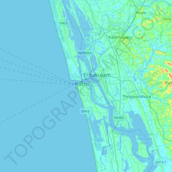
Name: Kochi topographic map, elevation, terrain.

Location: Kochi, Ernakulam, Kerala, 682005, India (9.77407 76.10063 10.09407 76.42063)

Average elevation: 4 m

Minimum elevation: -5 m

Maximum elevation: 73 m

Other topographic maps

Click on a map to view its topography, its elevation and its terrain.

Periyar River

India > Kerala > Kochi

Periyar River, Kochi, Ernakulam, Kerala, 683108, India

Average elevation: 7 m

Mangalavanam Bird WLS

India > Kerala > Kochi

Mangalavanam Bird WLS, Mathai Manjooran Road, ietty, Kacheripady, Kochi, Ernakulam, Kerala, 682012, India

Average elevation: 4 m

Periyar

India > Kerala > Kochi

Periyar, Kochi, Ernakulam, Kerala, KERALA 683544, India

Average elevation: 24 m

Sathar island

India > Kerala > Kochi

Sathar island, Kochi, Ernakulam, Kerala, India

Average elevation: 4 m

Vallarpadam

India > Kerala > Kochi

Vallarpadam, Kochi, Ernakulam, Kerala, 682504, India

Average elevation: 2 m

Chathari

India > Kerala > Kochi

Chathari, Kochi, Ernakulam, Kerala, 682301, India

Average elevation: 8 m

In order to remain free and to keep improving, this site uses cookies created by Google to compile visit statistics and display personalized advertisements.

How is the collected data used?