
Thank you for supporting this site ❤️
Make a donation
Make a donation
Chengalpattu topographic map
Click on the map to display elevation.
Thank you for supporting this site ❤️
Make a donation
Make a donation
Chengalpattu
Chengalpattu is located at 12°42′N 79°59′E / 12.7°N 79.98°E / 12.7; 79.98. It has an average elevation of 36 metres (118 ft). Lake Kolavai is the largest located in Chengalpattu.
Thank you for supporting this site ❤️
Make a donation
Make a donation
About this map
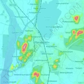
Name: Chengalpattu topographic map, elevation, terrain.
Location: Chengalpattu, Tamil Nadu, 603001, India (12.64409 79.94364 12.72409 80.02364)
Average elevation: 48 m
Minimum elevation: 25 m
Maximum elevation: 219 m
Thank you for supporting this site ❤️
Make a donation
Make a donation
Other topographic maps
Click on a map to view its topography, its elevation and its terrain.
Thank you for supporting this site ❤️
Make a donation
Make a donation
Thank you for supporting this site ❤️
Make a donation
Make a donation