
Thank you for supporting this site ❤️
Make a donation
Make a donation
Musandam topographic map
Click on the map to display elevation.
Thank you for supporting this site ❤️
Make a donation
Make a donation
About this map
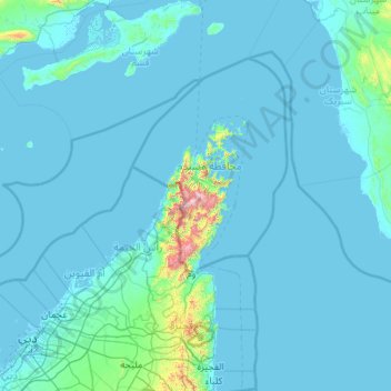
Name: Musandam topographic map, elevation, terrain.
Location: Musandam, Oman (24.99974 55.24986 26.99974 57.24986)
Average elevation: 57 m
Minimum elevation: -5 m
Maximum elevation: 1,956 m
Thank you for supporting this site ❤️
Make a donation
Make a donation
Other topographic maps
Click on a map to view its topography, its elevation and its terrain.
Thank you for supporting this site ❤️
Make a donation
Make a donation
Thank you for supporting this site ❤️
Make a donation
Make a donation