
United Kingdom topographic map
Interactive map
Click on the map to display elevation.
About this map
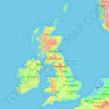
Name: United Kingdom topographic map, elevation, terrain.
Location: United Kingdom (49.67400 -14.01552 61.06100 2.09191)
Average elevation: 42 m
Minimum elevation: -6 m
Maximum elevation: 1,617 m
Scotland accounts for just under one-third (32 per cent) of the total area of the UK, covering 78,772 square kilometres (30,410 sq mi). This includes nearly 800 islands, predominantly west and north of the mainland; notably the Hebrides, Orkney Islands and Shetland Islands. Scotland is the most mountainous country in the UK and its topography is distinguished by the Highland Boundary Fault – a geological rock fracture – which traverses Scotland from Arran in the west to Stonehaven in the east. The fault separates two distinctively different regions; namely the Highlands to the north and west and the Lowlands to the south and east. The more rugged Highland region contains the majority of Scotland's mountainous land, including Ben Nevis which at 1,345 metres (4,413 ft) is the highest point in the British Isles. Lowland areas – especially the narrow waist of land between the Firth of Clyde and the Firth of Forth known as the Central Belt – are flatter and home to most of the population including Glasgow, Scotland's largest city, and Edinburgh, its capital and political centre, although upland and mountainous terrain lies within the Southern Uplands.
Other topographic maps
Click on a map to view its topography, its elevation and its terrain.
India
India
Average elevation: 1,017 m
Montreal
Canada > Quebec > Urban agglomeration of Montreal > Montreal
Montreal, Urban agglomeration of Montreal, Montreal (06), Quebec, H3B 1M7, Canada
Average elevation: 30 m
Hyderabad
India > Telangana > Bahadurpura mandal
Hyderabad, Bahadurpura mandal, Hyderabad District, Telangana, India
Average elevation: 549 m
Sri Lanka
Sri Lanka
Average elevation: 50 m
Nepal
Nepal
Average elevation: 2,604 m
Snohomish County
Snohomish County, Washington, United States
Average elevation: 649 m
Ocheretyne
Ocheretyne, Ocheretyne settlement hromada, Pokrovskii Raion, Donetsk Oblast, 86020, Ukraine
Average elevation: 227 m
Dehradun
India > Uttarakhand > Dehradun
Dehradun, Dehradun District, Uttarakhand, 248001, India
Average elevation: 904 m
Noida
India > Uttar Pradesh > Dadri
Noida, Dadri, Gautam Buddha Nagar District, Uttar Pradesh, 201301, India
Average elevation: 216 m
Bengaluru
India > Karnataka > Bangalore North
Bengaluru, Bangalore North, Bengaluru Urban District, Karnataka, India
Average elevation: 881 m
Haywood County
United States > North Carolina
Haywood County, North Carolina, United States
Average elevation: 1,044 m
Ooty Lake
India > Tamil Nadu > Udhagamandalam > Udhagamandalam
Ooty Lake, Udhagamandalam, The Nilgiris District, Tamil Nadu, 643001, India
Average elevation: 2,235 m
Pune
India > Maharashtra > Pune City > Pune
Pune, Pune City, Pune District, Maharashtra, 411001, India
Average elevation: 641 m
Kovilanchery
India > Tamil Nadu > Tambaram
Kovilanchery, Tambaram, Chengalpattu District, Tamil Nadu, 600126, India
Average elevation: 11 m
Tacoma
United States > Washington > Pierce County
Tacoma, Pierce County, Washington, United States
Average elevation: 67 m
Shangaime
Ecuador > Morona Santiago > Huamboya
Shangaime, Chiguaza, Huamboya, Morona Santiago, Ecuador
Average elevation: 810 m
Kandy
Kandy, Kandy District, Central Province, 20000, Sri Lanka
Average elevation: 621 m
Chennai
India > Tamil Nadu > Chennai
Chennai, Chennai District, Tamil Nadu, India
Average elevation: 8 m
Winterborne Kingston
United Kingdom > England > Dorset
Winterborne Kingston, Dorset, England, United Kingdom
Average elevation: 77 m
Pedda Arikatla
India > Andhra Pradesh > Konakanamitla
Pedda Arikatla, Konakanamitla, Prakasam, Andhra Pradesh, 523245, India
Average elevation: 119 m
Devanahalli
India > Karnataka > Devanahalli taluk
Devanahalli, Devanahalli taluk, Bengaluru Rural District, Karnataka, 562110, India
Average elevation: 900 m
city de boutet de monvel (ethanlecartographe
France > Grand Est > Meurthe-et-Moselle > Lunéville
city de boutet de monvel (ethanlecartographe, Lunéville, Meurthe-et-Moselle, Grand Est, Metropolitan France, 54300, France
Average elevation: 240 m
Haraluru
India > Karnataka > Tumkur taluk
Haraluru, Tumkur taluk, Tumakuru District, Karnataka, India
Average elevation: 864 m
Ruang
Indonesia > North Sulawesi > Kepulauan Siau Tagulandang Biaro > Pumpente
Ruang, Pumpente, Kepulauan Siau Tagulandang Biaro, North Sulawesi, Sulawesi, Indonesia
Average elevation: 274 m
Vairavanpatti
India > Tamil Nadu > Thiruppathur
Vairavanpatti, Thiruppathur, Sivagangai District, Tamil Nadu, 630207, India
Average elevation: 103 m
Mangaluru
India > Karnataka > Mangaluru taluk
Mangaluru, Mangaluru taluk, Dakshina Kannada District, Karnataka, 575001, India
Average elevation: 25 m
Madurai
India > Tamil Nadu > Madurai
Madurai, Madurai South, Madurai district, Tamil Nadu, India
Average elevation: 138 m