
Thank you for supporting this site ❤️
Make a donation
Make a donation
Ruang topographic map
Click on the map to display elevation.
Thank you for supporting this site ❤️
Make a donation
Make a donation
Ruang
Ruang is the southernmost stratovolcano in the Sangihe Islands arc, North Sulawesi, Indonesia. It comprises an island 4 by 5 kilometres (2.5 mi × 3.1 mi) wide. The summit contains a partial lava dome and reaches some 725 metres (2,379 ft) in altitude. From its summit, Klabat's peak in the south, that of Siau to the north, and Ternate to the east can all be seen.
Thank you for supporting this site ❤️
Make a donation
Make a donation
About this map
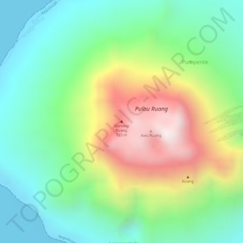
Name: Ruang topographic map, elevation, terrain.
Average elevation: 274 m
Minimum elevation: 0 m
Maximum elevation: 724 m
Thank you for supporting this site ❤️
Make a donation
Make a donation