
Siġġiewi topographic map
Interactive map
Click on the map to display elevation.
About this map
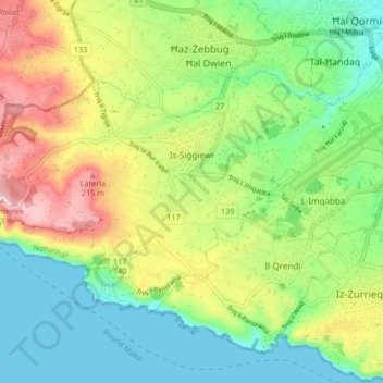
Name: Siġġiewi topographic map, elevation, terrain.
Location: Siġġiewi, Southern Region, SGW 1071, Malta (35.82602 14.38956 35.86856 14.47248)
Average elevation: 93 m
Minimum elevation: 0 m
Maximum elevation: 250 m
In its demographic and topographical formation, Siġġiewi followed a pattern common to other villages in Malta. Before the arrival of the Order of St John in 1530, there were other thriving hamlets in the area. Little by little, Ħal Xluq, Ħal Kbir, Ħal Niklusi, and Ħal Qdieri were absorbed in Siġġiewi and today only their secluded chapels remain.