
Minato topographic map
Interactive map
Click on the map to display elevation.
About this map
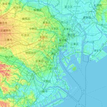
Name: Minato topographic map, elevation, terrain.
Location: Minato, Tokio, Japón (35.48323 139.58006 35.80323 139.90006)
Average elevation: 18 m
Minimum elevation: -8 m
Maximum elevation: 98 m
Other topographic maps
Click on a map to view its topography, its elevation and its terrain.
琵琶湖
Japón > 近畿地方 > Higashiōmi
琵琶湖, 滋賀県道52号栗見八日市線, Higashiōmi, Prefectura de Shiga, 近畿地方, Japón
Average elevation: 269 m
Región de Chūgoku
Prefectura de Okayama, Región de Chūgoku, Japón
Average elevation: 272 m
足柄上郡
Japón > Prefectura de Kanagawa
大井町, 足柄上郡, Prefectura de Kanagawa, 関東地方, 258-0016, Japón
Average elevation: 126 m