
東区 topographic map
Interactive map
Click on the map to display elevation.
About this map
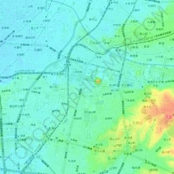
Name: 東区 topographic map, elevation, terrain.
Location: 東区, 名古屋市, 愛知県, 日本 (35.16936 136.90722 35.19944 136.96645)
Average elevation: 23 m
Minimum elevation: 7 m
Maximum elevation: 77 m
地形・地質の面からは、東区区域の大部分が名古屋台地(熱田台地)の海成段丘上(熱田面)に位置するが、区域のうちJR中央本線の東側の部分を中心に名古屋台地から外れ、一段低い地域となっている。JR中央本線西側の地域は大曽根地区などを除いて名古屋台地上の地域といえる。またJR中央本線沿いの地域は矢田川の氾濫によるものと考えられる大曽根面の地層となっており、地質的には名古屋台地の熱田面を2つに分ける形となっている。
Other topographic maps
Click on a map to view its topography, its elevation and its terrain.