
東谷山 topographic map
Interactive map
Click on the map to display elevation.
About this map
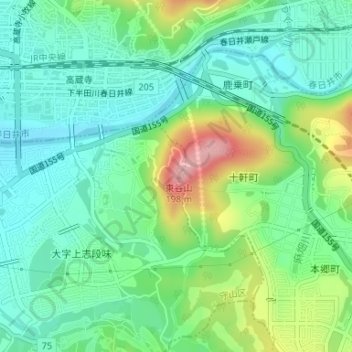
Name: 東谷山 topographic map, elevation, terrain.
Location: 東谷山, 国道155号, 守山区, 名古屋市, 愛知県, 4630001, 日本 (35.25583 137.05271 35.25593 137.05281)
Average elevation: 78 m
Minimum elevation: 29 m
Maximum elevation: 191 m
Other topographic maps
Click on a map to view its topography, its elevation and its terrain.