
守山区 topographic map
Interactive map
Click on the map to display elevation.
About this map
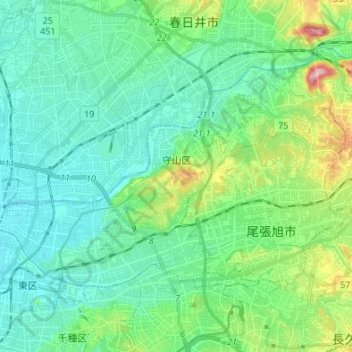
Name: 守山区 topographic map, elevation, terrain.
Location: 守山区, 名古屋市, 愛知県, 中部地方, 日本 (35.19007 136.92579 35.26023 137.06090)
Average elevation: 49 m
Minimum elevation: 8 m
Maximum elevation: 191 m
緑豊かな自然が残っており、名古屋市内としては比較的標高が高い土地が多い。北東端には市内最高峰(198m)の東谷山がある。
Other topographic maps
Click on a map to view its topography, its elevation and its terrain.