
天白区 topographic map
Interactive map
Click on the map to display elevation.
About this map
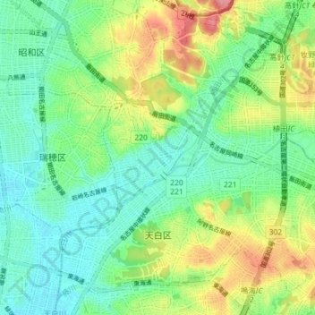
Name: 天白区 topographic map, elevation, terrain.
Location: 天白区, 名古屋市, 愛知県, 中部地方, 日本 (35.09942 136.94823 35.15275 137.01994)
Average elevation: 35 m
Minimum elevation: 3 m
Maximum elevation: 96 m
天白川および植田川周辺の平坦な地形と区北部の植田山、西部の音聞山、南部の相生山に見られるような丘陵地を合わせ持つ。また、平針の森にはトウカイモウセンゴケが生えており、また、子ども達の遊び場、豪雨時に水を蓄える役割をするため、住民にとって安心できる森であるものの、その一部の「平針の里山」はCOP10開催中の2010年から開発が始まり、河村たかし市長が買い取りを計画したり「平針の里山保全協議会」が保全に向けての取り組みをしたものの、2012年には住宅地として分譲を始めた。
Other topographic maps
Click on a map to view its topography, its elevation and its terrain.