
Myanmar topographic map
Interactive map
Click on the map to display elevation.
About this map
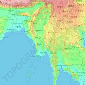
Name: Myanmar topographic map, elevation, terrain.
Location: Myanmar (9.52608 92.17292 28.54784 101.17008)
Average elevation: 569 m
Minimum elevation: -3 m
Maximum elevation: 7,762 m
In the north, the Hengduan Mountains form the border with China. Hkakabo Razi, located in Kachin State, at an elevation of 5,881 metres (19,295 ft), is the highest point in Myanmar. Many mountain ranges, such as the Rakhine Yoma, the Bago Yoma, the Shan Hills and the Tenasserim Hills exist within Myanmar, all of which run north-to-south from the Himalayas. The mountain chains divide Myanmar's three river systems, which are the Irrawaddy, Salween (Thanlwin), and the Sittaung rivers. The Irrawaddy River, Myanmar's longest river at nearly 2,170 kilometres (1,348 mi), flows into the Gulf of Martaban. Fertile plains exist in the valleys between the mountain chains. The majority of Myanmar's population lives in the Irrawaddy valley, which is situated between the Rakhine Yoma and the Shan Plateau.
Other topographic maps
Click on a map to view its topography, its elevation and its terrain.
Hyderabad
India > Telangana > Bahadurpura mandal
Hyderabad, Bahadurpura mandal, Hyderabad District, Telangana, India
Average elevation: 549 m
Montreal
Canada > Quebec > Urban agglomeration of Montreal > Montreal
Montreal, Urban agglomeration of Montreal, Montreal (06), Quebec, H3B 1M7, Canada
Average elevation: 30 m
Tacoma
United States > Washington > Pierce County
Tacoma, Pierce County, Washington, United States
Average elevation: 67 m
Sri Lanka
Sri Lanka
Average elevation: 50 m
Snohomish County
Snohomish County, Washington, United States
Average elevation: 649 m
India
India
Average elevation: 1,017 m
Ocheretyne
Ocheretyne, Ocheretyne settlement hromada, Pokrovskii Raion, Donetsk Oblast, 86020, Ukraine
Average elevation: 227 m
Dehradun
India > Uttarakhand > Dehradun
Dehradun, Dehradun District, Uttarakhand, 248001, India
Average elevation: 904 m
Haywood County
United States > North Carolina
Haywood County, North Carolina, United States
Average elevation: 1,044 m
Bhopal
India > Madhya Pradesh > Huzur Tahsil
Bhopal, Huzur Tahsil, Bhopal District, Madhya Pradesh, 462001, India
Average elevation: 498 m
Fernando Falcão
Fernando Falcão, Região Geográfica Imediata de Barra do Corda, Região Geográfica Intermediária de Imperatriz, Maranhão, Northeast Region, Brazil
Average elevation: 308 m
Bengaluru
India > Karnataka > Bangalore North
Bengaluru, Bangalore North, Bengaluru Urban District, Karnataka, India
Average elevation: 881 m
Nepal
Nepal
Average elevation: 2,604 m
Jite
India > Maharashtra > Mangaon
Jite, Mangaon, Raigad District, Maharashtra, India
Average elevation: 191 m
Labinsk
Russia > Krasnodar Krai > Labinsky District
Labinsk, Лабинское городское поселение, Labinsky District, Krasnodar Krai, Southern Federal District, Russia
Average elevation: 282 m
Mangaluru
India > Karnataka > Mangaluru taluk
Mangaluru, Mangaluru taluk, Dakshina Kannada District, Karnataka, 575001, India
Average elevation: 25 m
Madurai
India > Tamil Nadu > Madurai
Madurai, Madurai South, Madurai district, Tamil Nadu, India
Average elevation: 138 m
Baghpat
India > Uttar Pradesh > Baghpat
Baghpat, Baghpat District, Uttar Pradesh, 250609, India
Average elevation: 219 m
Loxford
Loxford, Cessnock City Council, New South Wales, 2326, Australia
Average elevation: 18 m
Pedda Arikatla
India > Andhra Pradesh > Konakanamitla
Pedda Arikatla, Konakanamitla, Prakasam, Andhra Pradesh, 523245, India
Average elevation: 119 m
Hagala State
Hagala State, Kandy District, Central Province, Sri Lanka
Average elevation: 1,050 m
Panwila
Panwila, Kandy District, Central Province, 20810, Sri Lanka
Average elevation: 755 m
Malvern
United Kingdom > England > Worcestershire > Malvern Hills
Malvern, Malvern Hills, Worcestershire, England, WR14 2HX, United Kingdom
Average elevation: 95 m
Mandi
India > Himachal Pradesh > Mandi
Mandi, Mandi District, Himachal Pradesh, 175001, India
Average elevation: 1,273 m
Musi River
Musi River, Hyderabad, Uppal mandal, Medchal–Malkajgiri, Telangana, 5000036, India
Average elevation: 490 m
Kurunegala
Sri Lanka > North Western Province
Kurunegala, Kurunegala District, North Western Province, 60000, Sri Lanka
Average elevation: 146 m
Lohar
India > Madhya Pradesh > Dewas Tahsil
Lohar, Dewas Tahsil, Dewas District, Madhya Pradesh, India
Average elevation: 522 m
Kasimov
Kasimov, Ryazan Oblast, Central Federal District, Russia
Average elevation: 124 m
Oryol
Oryol, Oryol Oblast, Central Federal District, Russia
Average elevation: 196 m
Kursk
Kursk, Kursk Oblast, Central Federal District, 305000, Russia
Average elevation: 192 m