
Thank you for supporting this site ❤️
Make a donation
Make a donation
Panwila topographic map
Click on the map to display elevation.
Thank you for supporting this site ❤️
Make a donation
Make a donation
About this map
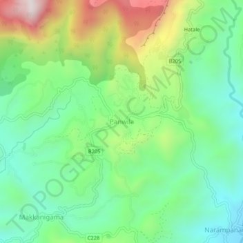
Name: Panwila topographic map, elevation, terrain.
Location: Panwila, Kandy District, Central Province, 20810, Sri Lanka (7.34168 80.69489 7.38168 80.73489)
Average elevation: 755 m
Minimum elevation: 476 m
Maximum elevation: 1,304 m
Thank you for supporting this site ❤️
Make a donation
Make a donation
Other topographic maps
Click on a map to view its topography, its elevation and its terrain.
Thank you for supporting this site ❤️
Make a donation
Make a donation
upper division, north meddecombra
Sri Lanka > Central Province > upper division, north meddecombra
Average elevation: 1,268 m