
City of Zagreb topographic map
Interactive map
Click on the map to display elevation.
City of Zagreb
Zagreb (/ˈzɑːɡrɛb/ ZAH-greb Croatian: [zǎːɡreb] ) is the capital and largest city of Croatia. It is in the north of the country, along the Sava river, at the southern slopes of the Medvednica mountain. Zagreb stands near the international border between Croatia and Slovenia at an elevation of approximately 158 m (518 ft) above sea level. In 2018, the population of the Zagreb urban agglomeration was 1,271,150, between a quarter and a third of the total population of Croatia, while at the 2021 census, the city itself had a population of 767,131.
About this map
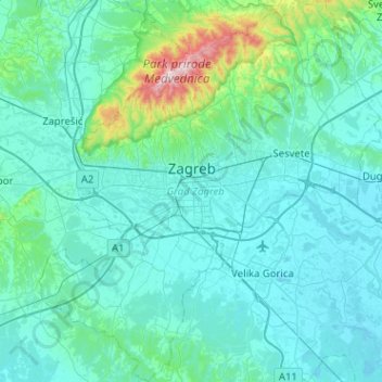
Name: City of Zagreb topographic map, elevation, terrain.
Location: City of Zagreb, Croatia (45.61395 15.77321 45.96915 16.23955)
Average elevation: 182 m
Minimum elevation: 96 m
Maximum elevation: 1,025 m
Other topographic maps
Click on a map to view its topography, its elevation and its terrain.
Đakovo
Đakovo is located 37 km (23 mi) to the southwest of Osijek and 34 km (21 mi) southeast of Našice; elevation 111 m. It is located near the motorway A5/E73, at the intersection of the state road D7 to Osijek, the arterial roads D38 to Požega, D46 to Vinkovci and the connecting road D515 to Našice.
Average elevation: 103 m
Zagreb
Croatia > City of Zagreb > Zagreb
Zagreb (/ˈzɑːɡrɛb, ˈzæɡrɛb, zɑːˈɡrɛb/ ZAH-greb, ZAG-reb, zah-GREB, Croatian: (listen)) is the capital and largest city of Croatia. It is in the northwest of the country, along the Sava river, at the southern slopes of the Medvednica mountain. Zagreb lies at an elevation of approximately 122 m…
Average elevation: 193 m