
越谷市 topographic map
Interactive map
Click on the map to display elevation.
About this map
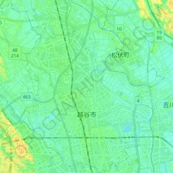
Name: 越谷市 topographic map, elevation, terrain.
Location: 越谷市, 埼玉県, 日本 (35.85472 139.74512 35.95857 139.84017)
Average elevation: 7 m
Minimum elevation: 1 m
Maximum elevation: 19 m
本市の地形はほぼ全域に渡って低平地で、平均海抜は5メートルほどであり、市街地と郊外部の水田から構成される。水はけが悪く、古くから大雨により度々水害を受けてきた地域である。
Other topographic maps
Click on a map to view its topography, its elevation and its terrain.