
Nordland topographic map
Interactive map
Click on the map to display elevation.
About this map
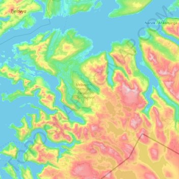
Name: Nordland topographic map, elevation, terrain.
Location: Ballangen, Nordland, 8540, Norway (68.05044 15.90143 68.44058 17.28854)
Average elevation: 404 m
Minimum elevation: -2 m
Maximum elevation: 1,712 m
Other topographic maps
Click on a map to view its topography, its elevation and its terrain.
Sande
Sande, Holmestrand, Vestfold og Telemark, 3070, Norway
Average elevation: 37 m
Porsgrunn
Porsgrunn, Vestfold og Telemark, Norway
Average elevation: 87 m
Olonkin City
Norway > Jan Mayen > Olonkin City
Olonkin City, Jan Mayen, Norway
Average elevation: 153 m