
Make a donation
Iran topographic map
Click on the map to display elevation.
Make a donation
Iran
Iran's topography is diverse and dominated by rugged mountain ranges, which define much of its landscape. To the west, the Zagros Mountains stretch from the northwest to the southeast, with many peaks surpassing 10,000 feet (3,048 meters) in elevation. These mountains form a rugged barrier between Iran's central plateau and the more fertile regions of the southwest. Further to the north, the Alborz Mountains flank the Caspian Sea, where Iran's highest peak, Mount Damavand (18,402 feet, 5,609 meters), is located. This mountainous terrain gives way to vast basins and desert plains, particularly in the central and eastern regions of the country. The Dasht-e Kavir and Dasht-e Lut, two prominent salt deserts, cover large areas and experience extreme temperatures and minimal rainfall. In contrast, the coastal regions along the Caspian Sea and Persian Gulf feature small, discontinuous plains. These varied landscapes create a dramatic and dynamic environment, affecting everything from climate to human settlement.
Make a donation
About this map
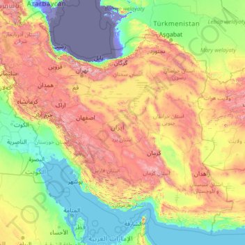
Name: Iran topographic map, elevation, terrain.
Location: Iran (24.83531 44.03189 39.78246 63.33327)
Average elevation: 786 m
Minimum elevation: -29 m
Maximum elevation: 4,807 m
Make a donation
Other topographic maps
Click on a map to view its topography, its elevation and its terrain.
Navi Mumbai
India > Maharashtra > Thane > Navi Mumbai
Navi Mumbai (Marathi pronunciation: , also known by its former name New Bombay), is a planned city off the west coast of the Indian state of Maharashtra in Konkan division. The city is divided into two parts, North Navi Mumbai and South Navi Mumbai, for the individual development of Panvel Mega City, which…
Average elevation: 30 m
Make a donation
Ankara
Ankara has a cold semi-arid climate (Köppen climate classification: BSk). Under the Trewartha climate classification, Ankara has a temperate humid continental climate (Dc). Due to its elevation and inland location, Ankara has cold and snowy winters, and hot and dry summers. Rainfall occurs mostly during the…
Average elevation: 1,082 m
Shimla
Shimla is on the south-western ranges of the Himalayas at 31°37′N 77°06′E / 31.61°N 77.10°E / 31.61; 77.10. It has an average altitude of 2,206 metres (7,238 ft) above mean sea level and extends along a ridge with seven spurs. The city stretches nearly 9.2 kilometres (5.7 mi) from east to west.
Average elevation: 1,557 m
Make a donation
Nainital
India > Uttarakhand > Nainital
The city of Nainital covers a total area of 11.73 km2 (4.53 sq mi), and is located at 29°23′N 79°27′E / 29.38°N 79.45°E / 29.38; 79.45, at an average elevation of 2,084 metres (6,837 ft) above sea level. The slopes of the nearby mountains are most populated, with an elevation ranging from…
Average elevation: 1,813 m
Varanasi
India > Uttar Pradesh > Sadar
Varanasi is located at an elevation of 80.71 metres (264.8 ft) in the centre of the Ganges valley of North India, in the Eastern part of the state of Uttar Pradesh, along the left crescent-shaped bank of the Ganges, averaging between 15 metres (50 ft) and 21 metres (70 ft) above the river. The city is the…
Average elevation: 77 m
Mumbai
Mumbai lies at the mouth of the Ulhas River on the western coast of India, in the coastal region known as the Konkan. It sits on Salsette Island (Sashti Island), which it partially shares with the Thane district. Mumbai is bounded by the Arabian Sea to the west. Many parts of the city lie just above sea level,…
Average elevation: 13 m
Make a donation
Make a donation
Maharashtra
Maharashtra is the third largest state by area in India. The Western Ghats better known as Sahyadri, are a hilly range running parallel to the coast, at an average elevation of 1,200 metres (4,000 ft). Kalsubai, a peak in the Sahyadris, near Nashik city is the highest elevated point in Maharashtra. To the west…
Average elevation: 478 m
Leh
Leh (/ˈlɛ/) (Ladakhi: གླེ) is the joint capital and largest city of Ladakh, a union territory of India. Leh, located in the Leh district, was also the historical capital of the Kingdom of Ladakh, the seat of which was in the Leh Palace, the former residence of the royal family of Ladakh, built in the…
Average elevation: 4,294 m
Dehradun
India > Uttarakhand > Dehradun
The city of Dehradun mainly lies in Doon Valley and is at a varying height from 410 m (1,350 ft) in Clement Town to above 700 m (2,300 ft) at Malsi which is 15 km (9.3 mi) from the city. However, the average elevation is 450 m (1,480 ft) above sea level. Malsi is the starting point of Lesser Himalayan Range…
Average elevation: 904 m
Mahendragiri
India > Odisha > Ramagiri > Burakhat
Mahendragiri, is a mountain in Rayagada block of the district of Gajapati, Odisha, India. It is situated amongst the Eastern Ghats at an elevation of 1,501 metres (4,925 ft). The second highest motorable mountain of Odisha and 8th highest peak of Odisha.
Average elevation: 1,108 m
Make a donation
Clement Town
India > Uttarakhand > Dehradun > Dehradun
Clement Town has an average elevation of 410 metres (1,350 ft).
Average elevation: 610 m
Chakrata
India > Uttarakhand > Chakrata
It lies between the Tons and Yamuna rivers, at an elevation of 2118 m, 98 km from the state capital, Dehradun. Chakrata was originally a cantonment of the British Indian Army. To the west lies Shillai, Himachal Pradesh, and to the east are Mussoorie (73 km) and Tehri Garhwal.
Average elevation: 1,851 m
Khammam
India > Telangana > Khammam Urban mandal
Khammam is located at 17°15′N 80°09′E / 17.25°N 80.15°E / 17.25; 80.15. It has an average elevation of 108 metres (390 feet).
Average elevation: 130 m
Make a donation
Harapanahalli
India > Karnataka > Harapanahalli taluku
It has an average elevation of 633 metres (2,077 ft) above the Mean sea level. Harapanahalli is surrounded by several districts like Davanagere in the South, Chithradurga in the Southeast, Haveri in the West.
Average elevation: 626 m
Hardoi
India > Uttar Pradesh > Hardoi
Hardoi is located at 27°25′N 80°07′E / 27.42°N 80.12°E / 27.42; 80.12. It has an average elevation of 134 metres (440 ft). Hardoi is located 110 km from Lucknow (capital of Uttar Pradesh) and 394 from New Delhi (capital of India). The Ganges and several of its tributaries are crossing the…
Average elevation: 141 m
Make a donation
Make a donation
Dharamshala
India > Himachal Pradesh > Dharamshala
Dharamshala has an average elevation of 1,457 m (4,780 ft), covering an area of almost 8.51 km2 (3.29 sq mi). Dharamsala is located in the Kangra Valley, in the shadow of the Dhauladhar mountains.
Average elevation: 1,781 m
Make a donation
Madanapalle
India > Andhra Pradesh > Madanapalle
It is located at an average elevation of 695 m (2,280 ft) above mean sea level.
Average elevation: 727 m
Bhubaneshwar
India > Odisha > Bhubaneswar (M.Corp.)
Bhubaneswar is in Khordha district of Odisha. It is in the eastern coastal plains, along the axis of the Eastern Ghats mountains. The city has an average altitude of 45 m (148 ft) above sea level. It lies southwest of the Mahanadi River that forms the northern boundary of Bhubaneswar metropolitan area, within…
Average elevation: 30 m
Bhopal
India > Madhya Pradesh > Huzur Tahsil
Bhopal has an average elevation of 500 metres (1401 ft) and is located in the central part of India, just north of the upper limit of the Vindhya mountain ranges. Located on the Malwa plateau, it is higher than the north Indian plains and the land rises towards the Vindhya Range to the south. The city has…
Average elevation: 498 m
Make a donation
Make a donation
Make a donation
Guwahati
Professor Abani Kumar Bhagawati of Gauhati University stated that since before there were sufficient wetlands to absorb rainwater and channels to carry excess water to the Brahmaputra, the city did not experience floods. However, human interference has disrupted the natural topography, leading to the current…
Average elevation: 113 m
Kolkata
Spread roughly north–south along the east bank of the Hooghly River, Kolkata sits within the lower Ganges Delta of eastern India approximately 75 km (47 mi) west of the international border with Bangladesh; the city's elevation is 1.5–9 m (5–30 ft). Much of the city was originally a wetland that was…
Average elevation: 5 m
Salem
Salem is located at 11°40′N 78°08′E / 11.67°N 78.14°E / 11.67; 78.14, at an average elevation of 278 m (912 ft). The city is surrounded by hills: Nagaramalai on the north, Jarugumalai on the south, Kanjamalai on the west, Godumalai on the east and the Shevaroy Hills on the northeast.…
Average elevation: 418 m
Make a donation
Tirunelveli
India > Tamil Nadu > Tirunelveli
Tirunelveli is located at 8°43′41.82″N 77°41′43.94″E / 8.7282833°N 77.6955389°E / 8.7282833; 77.6955389, and its average elevation is 47 metres (154 ft). It is located at the southernmost tip of the Deccan plateau. The Tamirabarani River divides the city into the Tirunelveli quarter and…
Average elevation: 48 m
Make a donation
Make a donation
Make a donation
Make a donation
Make a donation
Cumbum
India > Tamil Nadu > Uthamapalayam
Cumbum is located at 9°44′N 77°18′E / 9.73°N 77.3°E / 9.73; 77.3. It has an average elevation of 391meters (1282 feet). One can see the backdrop of Kodaikanal Hills from Cumbum. Apart from that Cumbum has most vigorous activity in agriculture.
Average elevation: 432 m
Vagamon
Vagamon, due to its elevation and climate, has a unique ecosystem, leading to the emergence of rich natural vegetation, plant species, shola forests etc. From the early 20th century plantation crops like tea, coffee started. Vagamon hills are home to less explored flora and fauna. A faunal diversity study…
Average elevation: 866 m
Make a donation
Vellore
India > Tamil Nadu > Vellore
Vellore is at 12°55′N 79°08′E / 12.92°N 79.13°E / 12.92; 79.13, 220m above sea level. The city has a tropical savanna climate. It is in the Vellore district of the South Indian state, Tamil Nadu, 135 km (84 mi) west of the state capital Chennai and 30 km (19 mi) kms South of its twin city…
Average elevation: 283 m
Bilimora
India > Gujarat > Gandevi Taluka
Bilimora is located at 20°45′N 72°57′E / 20.75°N 72.95°E / 20.75; 72.95. It has an average elevation of 4 metres (13 ft). Bilimora is the second largest city in the Navsari district after Navsari city. The city is supposed to have been surrounded by three rivers: Ambika from the north, Kaveri…
Average elevation: 11 m
Make a donation
Yercaud
India > Tamil Nadu > Yercaud
Yercaud, also spelt Erkad, is a town and hill station in Salem District in Tamil Nadu, India. Located in Servarayan Hills in the Eastern Ghats, it is situated at an altitude of 1,515 m (4,970 ft).
Average elevation: 1,092 m
Khambhat
India > Gujarat > Khambhat Taluka
Khambhat is at 22°18′N 72°37′E / 22.3°N 72.62°E / 22.3; 72.62. It has an average elevation of 8 metres (26 ft).
Average elevation: 11 m
Make a donation
Make a donation
Vellarada
India > Kerala > Neyyattinkara
Vellarada is also known for its hilltop shrine "Kurisumala Pilgrim Centre" (also called Thekkan kurisumala) at an elevation of 640 metres (2,100 ft). Thousands of devotees from various parts of Tamil Nadu, Kerala, Andhra Pradesh and Karnataka visit the shrine during Lent every year.
Average elevation: 124 m
Anupgarh
India > Rajasthan > Anupgarh Tehsil
Anupgarh has an average elevation of 155 metres (508 feet), and is very close to the border with Pakistan. The fort at Anupgarh was built about 1689 by the Mughal governor to help suppress the local Bhati Rajputs who were rebelling.
Average elevation: 155 m
Make a donation
Make a donation
Make a donation