
City of London topographic map
Interactive map
Click on the map to display elevation.
About this map
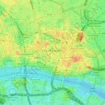
Name: City of London topographic map, elevation, terrain.
Location: City of London, Greater London, England, United Kingdom (51.50687 -0.11383 51.52331 -0.07276)
Average elevation: 21 m
Minimum elevation: -1 m
Maximum elevation: 44 m
The elevation of the City ranges from sea level at the Thames to 21.6 metres (71 ft) at the junction of High Holborn and Chancery Lane. Two small but notable hills are within the historic core, Ludgate Hill to the west and Cornhill to the east. Between them ran the Walbrook, one of the many "lost" rivers or streams of London (another is the Fleet).
Other topographic maps
Click on a map to view its topography, its elevation and its terrain.
Winterborne Kingston
United Kingdom > England > Dorset
Winterborne Kingston, Dorset, England, United Kingdom
Average elevation: 77 m
Malham
United Kingdom > England > North Yorkshire
Malham, North Yorkshire, England, United Kingdom
Average elevation: 371 m
Malvern
United Kingdom > England > Worcestershire > Malvern Hills
Malvern, Malvern Hills, Worcestershire, England, WR14 2HX, United Kingdom
Average elevation: 95 m
Cow Hill
United Kingdom > England > North Yorkshire > Halton West
Cow Hill, Halton West, North Yorkshire, England, BD23 4LP, United Kingdom
Average elevation: 145 m
Newport
United Kingdom > England > Isle of Wight
Newport, Isle of Wight, England, PO30 5HD, United Kingdom
Average elevation: 45 m
Manchester
Manchester, Greater Manchester, England, United Kingdom
Average elevation: 66 m
Mullion
United Kingdom > England > Cornwall
Mullion, Cornwall, England, United Kingdom
Average elevation: 45 m
Wallsend
United Kingdom > England > North Tyneside
Wallsend, North Tyneside, North of Tyne, England, NE28 8QS, United Kingdom
Average elevation: 41 m
Siston
United Kingdom > England > South Gloucestershire
Siston, South Gloucestershire, West of England, England, United Kingdom
Average elevation: 80 m
Colsterworth
United Kingdom > England > Lincolnshire > South Kesteven
Colsterworth, South Kesteven, Lincolnshire, England, United Kingdom
Average elevation: 114 m
Coleby
United Kingdom > England > Lincolnshire > North Kesteven
Coleby, North Kesteven, Lincolnshire, England, LN5 0AG, United Kingdom
Average elevation: 50 m
Metropolitan Borough of Solihull
Metropolitan Borough of Solihull, West Midlands Combined Authority, England, United Kingdom
Average elevation: 119 m
Dowlish Ford
United Kingdom > England > Somerset > Ilminster
Dowlish Ford, Ilminster, Somerset, England, TA19 0PE, United Kingdom
Average elevation: 67 m
Axminster
United Kingdom > England > Devon > East Devon
Axminster, East Devon, Devon, England, United Kingdom
Average elevation: 86 m
Huddersfield
United Kingdom > England > Kirklees
Huddersfield, Kirklees, West Yorkshire, England, HD1 2AA, United Kingdom
Average elevation: 145 m
Aylesbury
United Kingdom > England > Buckinghamshire
Aylesbury, Buckinghamshire, England, United Kingdom
Average elevation: 85 m
Langport
United Kingdom > England > Somerset
Langport, Somerset, England, United Kingdom
Average elevation: 18 m
Granby
United Kingdom > England > Nottinghamshire > Rushcliffe
Granby, Sutton, Rushcliffe, Nottinghamshire, England, United Kingdom
Average elevation: 32 m
Alston
United Kingdom > England > Westmorland and Furness
Alston, Westmorland and Furness, England, CA9 3RF, United Kingdom
Average elevation: 404 m
Milton
United Kingdom > England > Cumberland > Brampton
Milton, Brampton, Cumberland, England, CA8 1HX, United Kingdom
Average elevation: 139 m
Biggin CP
United Kingdom > England > Derbyshire > Derbyshire Dales
Biggin CP, Derbyshire Dales, Derbyshire, England, United Kingdom
Average elevation: 188 m
Heathcote
United Kingdom > England > Derbyshire > Derbyshire Dales
Heathcote, Derbyshire Dales, Derbyshire, England, SK17 0AY, United Kingdom
Average elevation: 309 m
Sutton
United Kingdom > England > Kingston upon Hull
Sutton, Kingston upon Hull, England, HU7 4UF, United Kingdom
Average elevation: 3 m
Craster
United Kingdom > England > Northumberland
Craster, Northumberland, North of Tyne, England, United Kingdom
Average elevation: 16 m
Richmond Park
United Kingdom > England > London
Richmond Park, London Borough of Richmond upon Thames, London, Greater London, England, United Kingdom
Average elevation: 26 m
Harrold
United Kingdom > England > Bedford
Harrold, Bedford, England, MK43 7DA, United Kingdom
Average elevation: 66 m
Oxshott
United Kingdom > England > Surrey > Elmbridge
Oxshott, Elmbridge, Surrey, England, KT22 0SN, United Kingdom
Average elevation: 47 m
Bagpath
United Kingdom > England > Gloucestershire > Cotswold District
Bagpath, Kingscote, Cotswold District, Gloucestershire, England, GL8 8YG, United Kingdom
Average elevation: 198 m
Baslow
United Kingdom > England > Derbyshire > Derbyshire Dales
Baslow, Derbyshire Dales, Derbyshire, England, DE45 1HS, United Kingdom
Average elevation: 180 m
Cow Down
United Kingdom > England > Hampshire > Test Valley
Cow Down, Test Valley, Hampshire, England, SP11 9HE, United Kingdom
Average elevation: 193 m
Blackpool
United Kingdom > England > Borough of Blackpool
Blackpool, Borough of Blackpool, England, FY1 1DL, United Kingdom
Average elevation: 7 m
Acklington
United Kingdom > England > Northumberland
Acklington, Northumberland, North of Tyne, England, United Kingdom
Average elevation: 36 m
Hadstone Carrs
United Kingdom > England > Northumberland > Togston
Hadstone Carrs, Togston, Northumberland, North of Tyne, England, United Kingdom
Average elevation: 3 m
Bentley Heath
United Kingdom > England > Metropolitan Borough of Solihull
Bentley Heath, Metropolitan Borough of Solihull, West Midlands Combined Authority, England, B93 9BL, United Kingdom
Average elevation: 126 m
Kidsgrove
United Kingdom > England > Staffordshire > Kidsgrove
Kidsgrove, Newcastle-under-Lyme, Staffordshire, England, United Kingdom
Average elevation: 161 m
Wingfield
United Kingdom > England > Suffolk > Mid Suffolk
Wingfield, Mid Suffolk, Suffolk, England, United Kingdom
Average elevation: 46 m
Marlow
United Kingdom > England > Buckinghamshire
Marlow, Buckinghamshire, England, United Kingdom
Average elevation: 51 m
Hanley
United Kingdom > England > Stoke-on-Trent
Hanley, Stoke-on-Trent, England, ST1 1LD, United Kingdom
Average elevation: 154 m
Caddington
United Kingdom > England > Central Bedfordshire
Caddington, Central Bedfordshire, England, United Kingdom
Average elevation: 165 m
Southend-on-Sea
United Kingdom > England > Essex
Southend-on-Sea, Essex, England, SS1 1JX, United Kingdom
Average elevation: 12 m
Borough of Runnymede
United Kingdom > England > Surrey
Borough of Runnymede, Surrey, England, United Kingdom
Average elevation: 34 m
Tintagel
United Kingdom > England > Cornwall
Tintagel, Cornwall, England, United Kingdom
Average elevation: 89 m
Cramlington
United Kingdom > England > Northumberland
Cramlington, Northumberland, North of Tyne, England, United Kingdom
Average elevation: 53 m
Hoddesdon
United Kingdom > England > Hertfordshire
Hoddesdon, Broxbourne, Hertfordshire, England, EN11 8UD, United Kingdom
Average elevation: 54 m
Exmouth
United Kingdom > England > Devon > East Devon
Exmouth, East Devon, Devon, England, United Kingdom
Average elevation: 29 m