
Thank you for supporting this site ❤️
Make a donation
Make a donation
Langport topographic map
Click on the map to display elevation.
Thank you for supporting this site ❤️
Make a donation
Make a donation
About this map
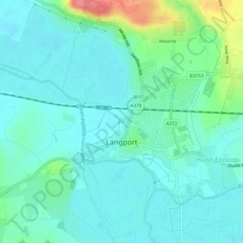
Name: Langport topographic map, elevation, terrain.
Location: Langport, Somerset, England, United Kingdom (51.03474 -2.83852 51.04492 -2.82021)
Average elevation: 18 m
Minimum elevation: 2 m
Maximum elevation: 76 m
Thank you for supporting this site ❤️
Make a donation
Make a donation
Other topographic maps
Click on a map to view its topography, its elevation and its terrain.