
Malham topographic map
Click on the map to display elevation.
About this map
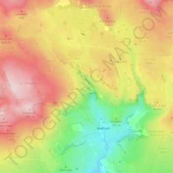
Name: Malham topographic map, elevation, terrain.
Location: Malham, North Yorkshire, England, United Kingdom (54.05408 -2.20986 54.09540 -2.11451)
Average elevation: 371 m
Minimum elevation: 178 m
Maximum elevation: 552 m
Other topographic maps
Click on a map to view its topography, its elevation and its terrain.
Greenhow Hill
United Kingdom > England > North Yorkshire
The village is about 3 miles (4.8 km) west of Pateley Bridge on the road heading towards Grassington, and is mainly in the civil parish of Bewerley. However, the western end of the village lying to the west of Kell Dyke, commonly known as Craven Cross, lies within the civil parish of Appletreewick in Craven.…
Average elevation: 358 m