
Thank you for supporting this site ❤️
Make a donation
Make a donation
Southend-on-Sea topographic map
Click on the map to display elevation.
Thank you for supporting this site ❤️
Make a donation
Make a donation
About this map
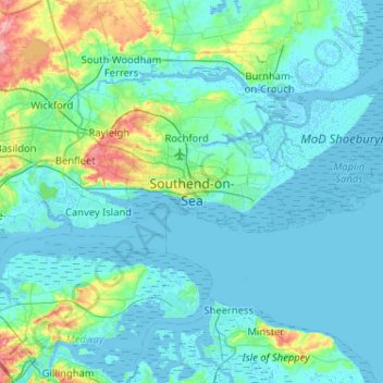
Name: Southend-on-Sea topographic map, elevation, terrain.
Location: Southend-on-Sea, Essex, England, SS1 1JX, United Kingdom (51.37882 0.55281 51.69882 0.87281)
Average elevation: 12 m
Minimum elevation: -4 m
Maximum elevation: 96 m
Thank you for supporting this site ❤️
Make a donation
Make a donation
Other topographic maps
Click on a map to view its topography, its elevation and its terrain.
Canvey Island
United Kingdom > England > Essex > Castle Point > Newlands
In 1607 the Elizabethan antiquarian William Camden noted in his work Britannia (a topographical and historical survey of all of Great Britain and Ireland) that Canvey Island (which he called Island Convennon) was documented in the 2nd century by the Alexandrian geographer Ptolemy. In his work Geographia,…
Average elevation: 10 m
Thank you for supporting this site ❤️
Make a donation
Make a donation