
久賀島 topographic map
Interactive map
Click on the map to display elevation.
About this map
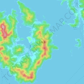
Name: 久賀島 topographic map, elevation, terrain.
Location: 久賀島, 五島市, 長崎県, 日本 (32.76343 128.83234 32.84479 128.91068)
Average elevation: 43 m
Minimum elevation: -2 m
Maximum elevation: 338 m
五島列島の中では福江島・中通島に次いで3番目に大きい島で、福江島の北東、奈留島の南西に位置する。福江島とは田ノ浦瀬戸、奈留島とは奈留瀬戸が隔てる。海岸線はリアス式海岸で、特に島の北側から中央にかけて久賀湾が大きく切れ込んで馬蹄形の地形となっている。島の南西には田ノ浦港があり、定期船が発着している。
Other topographic maps
Click on a map to view its topography, its elevation and its terrain.