
豊田市 topographic map
Interactive map
Click on the map to display elevation.
About this map
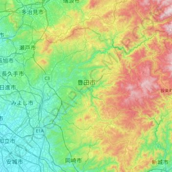
Name: 豊田市 topographic map, elevation, terrain.
Location: 豊田市, 愛知県, 中部地方, 日本 (34.99060 137.04006 35.29116 137.58113)
Average elevation: 359 m
Minimum elevation: 2 m
Maximum elevation: 1,222 m
挙母地区は、その南端にある「鵜の首」を出口とした盆地地形となっており、豊田盆地もしくは挙母盆地と呼ばれている。矢作川が狭くなる鵜の首により度々氾濫が起こり、その氾濫により盆地が形成されたが、この鵜の首の川幅を広げる工事が進められている。
Other topographic maps
Click on a map to view its topography, its elevation and its terrain.