
Gifu Prefecture topographic map
Interactive map
Click on the map to display elevation.
About this map
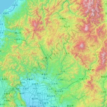
Name: Gifu Prefecture topographic map, elevation, terrain.
Location: Gifu Prefecture, Chubu Region, Japan (35.13373 136.27622 36.46507 137.65305)
Average elevation: 750 m
Minimum elevation: -4 m
Maximum elevation: 3,132 m
Because the Mino region is surrounded by low mountains, the temperature fluctuates through the year, from hot summers to cold winters. The eastern city of Tajimi, for example, often records the hottest temperature in Japan each year and is considered to be the hottest city within Honshū boasting an average daytime high of 34.1 °C (93.4 °F) during the peak of summer. On August 16, 2007, Tajimi set the record for the hottest day recorded in Japan's history—40.9 °C (105.6 °F). Summers are hotter, as the landlocked area becomes a heat island, and the temperature rises even further when hot, dry foehn winds blow over the Ibuki Mountains from the Kansai region. The Hida region, with its higher elevation and northerly latitude, is significantly cooler than the Mino region, although there are sometimes extremely hot days there too. The Hida region is more famous for its harsh winters, bringing extremely heavy snowfall, especially in the northwestern areas. Gifu boasts a high amount of skiing locations. Shōkawa-chō, part of the city of Takayama, is up in the mountains, and its location has led it to be called the coldest inhabited place on Honshū.
Other topographic maps
Click on a map to view its topography, its elevation and its terrain.
Motoyama
Motoyama, Nagaoka County, Kochi Prefecture, 781-3601, Japan
Average elevation: 679 m
Niki
Niki, Yoichi County, Shiribeshi Subprefecture, Hokkaido Prefecture, Japan
Average elevation: 269 m
Kusatsu
Kusatsu, Agatsuma County, Gunma Prefecture, Japan
Average elevation: 1,171 m
Kansai Region
Japan > Chubu Region > Nagoya
Kansai Region, Joto, Osaka Prefecture, Japan
Average elevation: 194 m
Nidan Fall
Nidan Fall, Matsumoto, Nagano Prefecture, Japan
Average elevation: 2,048 m
Jodogahama Observation Spot
Jodogahama Observation Spot, 浄土ヶ浜自然歩道, 鍬ヶ崎, Miyako, Iwate Prefecture, 027-0076, Japan
Average elevation: 22 m
Tsuwano
Tsuwano, Kanoashi County, Shimane Prefecture, Japan
Average elevation: 330 m